- 1UPSC CSE I - 2026Which of the following statements with reference to Lake Turkana is/are correct?
- It is the largest desert lake in the world.
- The lake is situated in South Sudan along the eastern fringe of the Sahara desert.
- The lake is listed as a UNESCO World Heritage Site and is also referred to as the 'Jade Sea'.
Select the answer using the code given below : - 2UPSC CSE I - 2025Consider the following countries :
- Bolivia
- Brazil
- Colombia
- Ecuador
- Paraguay
- Venezuela
Andes mountains pass through how many of the above countries? - 3UPSC CSE I - 2024The longest border between any two countries in the world is between :
- 4UPSC CSE I - 2022Which one of the following lakes of West Africa has become dry and turned into a desert ?
- 5UPSC CSE I - 2021With reference to India, Didwana, Kuchaman, Sargol and Khatu are the names of
- 6UPSC CSE I - 2020Siachen Glacier is situated to the
- 7UPSC CSE I - 2020
Consider the following pairs:
River Flows into 1. Mekong Andaman Sea 2. Thames Irish Sea 3. Volga Caspian Sea 4. Zambezi Indian Ocean Which of the pairs given above is/are correctly matched?
- 8UPSC CSE I - 2017Mediterranean Sea is a border of which of the following countries ?
- Jordan
- Iraq
- Lebanon
- Syria
Select the correct answer using the code given below : - 9UPSC CSE I - 2014Turkey is located between
- 10UPSC CSE I - 2013Which one of the following pairs is correctly matched?Geographical Feature - Region
- 11UPSC CSE I - 2009
Which one of the following pairs is not correctly matched?
City River (a) Berlin Rhine (b) London Thames (c) New York Hudson (d) Vienna Danube - 12UPSC CSE I - 2009Match List-I (Geographic Feature) with List-II (Country) and select the correct answer using the code given below the lists:
List-I (Geographic
feature)List-II (Country) A. Great Victoria Desert 1. Australia B. Grand Canyon 2. Canada C. Lake Winnipeg 3. New Zealand D. Southern Alps 4. USA - 13UPSC CSE I - 2007
Which one among the following rivers is the longest?
- 14UPSC CSE I - 2007
Where is Copacabana Beach located?
- 15UPSC CSE I - 2007
Match List-I (City) with List-II (River) and select the correct answer using the code given below:
List-I (City) List-II (River) A. Bangkok 1. Irrawaddy B. Phnom-Penh 2. Mekong C. Hanoi 3. Menam (Chao Phraya) D. Yangon 4. Red River Codes:
- 16UPSC CSE I - 2007
Through which one of the following Straits, does a tunnel connect the United Kingdom and France?
- 17UPSC CSE I - 2006
Bermuda Triangle extends up to which of the following places?
- Southern Florida
- Puerto Rico
- Hawaiian Islands
Select the correct answer using the codes given below:
- 18UPSC CSE I - 2006
Huangpu River flows through which one of the following cities?
- 19UPSC CSE I - 2005
Where are the Balearic Islands located?
- 20UPSC CSE I - 2005
Match List-I (City) with List-II (River) and select the correct answer using the codes given below the lists:
List-I (City) List-II (River) A. Washington, D.C. 1. River Manzanares B. Berlin 2. River Seine C. Paris 3. River Spree D. Madrid 4. River Potomac Codes:
- 21UPSC CSE I - 2004
The great Asian river Mekong does not run through:
- 22UPSC CSE I - 2004
Lake Sambhar is nearest to which one of the following cities of Rajasthan?
- 23UPSC CSE I - 2004
Which one of the following does not border Panama?
- 24UPSC CSE I - 2003
The waterfall 'Victoria' is associated with the river:
- 25UPSC CSE I - 2002
In the map given below, four islands of the Indian Ocean region, i.e.,
- Seychelles,
- Chagos,
- Mauritius, and
- Socotra
are marked as 1, 2, 3, and 4. Match them and select the correct answer from the codes given below:
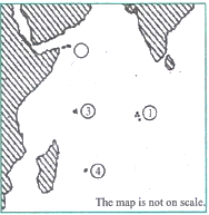
Codes:
- 26UPSC CSE I - 2000
Consider the following provinces of former Yugoslavia:
- Bosnia
- Croatia
- Slovenia
- Yugoslavia.
- 27UPSC CSE I - 2000
Which one of the following lakes forms an international boundary between Tanzania and Uganda ?
- 28UPSC CSE I - 1999
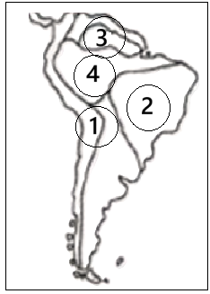
Physical regions marked as 1, 2, 3, & 4 on the given map are respectively:
- 29UPSC CSE I - 1998
Match the rivers labelled A, B, C, and D on the given map with their names from the list and select the correct Answer:
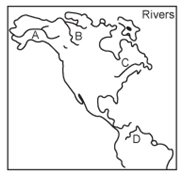
List-I List-II A 1. St. Lawrence B 2. Orinoco C 3. Mackenzie D 4. Amazon 5. Yukon Codes
- 30UPSC CSE I - 1997
From Aceh in the far northwest to Torres Strait in the east is 5000 miles, almost as far as from London to Baghdad. The archipelago has 14,000 islands, some mere equatorial rocks, others some of the largest in the world." This description best fits:
- 31UPSC CSE I - 1996
A rough outline map of northern Sri Lanka is shown below. Jaffna is located at the point marked:
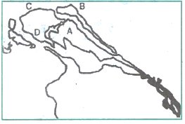
- 32UPSC CSE I - 1996
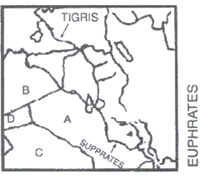
The rough outline map shows a portion of the Middle East. The countries labelled A, B, C and D are respectively: